Photo by @ Admin
Enrolment Zone
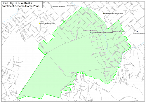
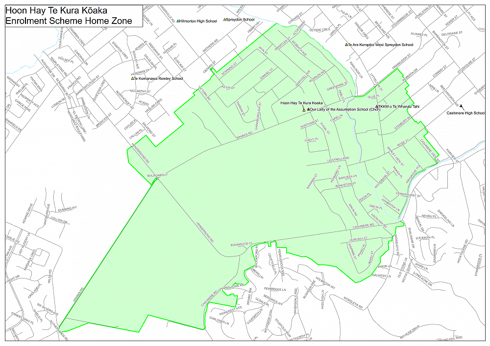
Following the consultation at the end of last year, we have been advised from the Ministry of Education that our enrolment zone will change from the beginning of Term 2, 2022.
Here is the map, and the description is below - the main difference is that we no longer have all of Westmorland in our zone.
HOON HAY TE KURA KŌAKA (#3379)Enrolment Scheme Description
Amendment commencing 02 May 2022
Home Zone
All students who live within the home zone described below shall be eligible to enrol at the school.
From the intersection of Hendersons Road and Sparks Road
- North East along Sparks Road to Victors Road
- Including Hawthorne Park
- Including Hendersons Road addresses to 184 (even numbers) and 225 (odd numbers)
- North West along Victors Road to Newland Street
- Including all Victors Road addresses
- North East along Newland Street to Kevin Street
- North West along Kevin Street to Downing Street
- Including all Kevin Street addresses
- North East along Downing Street to Wyn Street
- South East along Wyn Street to Lewis Street
- North East along Lewis Street to Hoon Hay Road
- South East along Hoon Hay Road to Smartlea Street
- Including Hoon Hay Road addresses down to 84 (even numbers) and 89 (odd numbers)
- North East along Smartlea Street to the Ōpāwaho (Heathcote) River
- Including Weir Place
- South East along the south west bank of the Ōpāwaho (Heathcote) River to Sparks Road.
- East along the south side only of Sparks Road to Lyttelton Street
- Including addresses on the South side of Frankleigh Street to address number 32b
- South along Lyttelton Street to Rose Street
- Including Roberta Drive to addresses 39 (odd numbers) and 40 (even numbers), including Merle Place
- Including Conway Street to addresses 47a (odd numbers) and 46 (even numbers)
- Including Stanbury Avenue to addresses 37 (odd numbers) and 44 (even numbers)
- North East along Rose Street to Cashmere View Street
- Including Rose Street addresses between Cashmere View Street and Fairview Street (including 81 Rose Street)
- South East along Cashmere View Street to Ashgrove Terrace
- South West along Ashgrove Terrace to the end of the street
- South East across the Ōpāwaho (Heathcote) River to the Cashmere Road / Shalamar Drive intersection
- West along Cashmere Road to Worsleys Road
- South along Worsleys Road to Hurunui Street
- West along Hurunui Street to Waiau Street
- South along Waiau Street to Waipara Street
- North along Waipara Street to Hurunui Street
- East along Hurunui Street to Opihi Street
- Including all addresses on Hurunui Street
- North along Opihi Street to Cashmere Road
- West along Cashmere Road to Hendersons Road
- North West along Hendersons Road to Sparks Road
- Including Cashmere Road addresses to number 482
- Including the south east side of Sparks Road between Hendersons Road and Milns Road
Addresses on both sides of boundary roads are considered in-zone unless specified otherwise.
Gallery